
Culture & tourism
Planning events with an interactive 3D venue map
Planning an event from a few photos and a blueprint
When we started showing aerial 3D scans to venues and event people, one event organiser said something that stuck. Often all they get from a venue is a few photos and maybe a blueprint. From that, they're supposed to plan stages, crowd flow and catering, sometimes for a site hundreds of kilometres away.
Their point was simple: if a venue could hand over an accurate 3D scan of the place, they'd be a lot more attractive to book.
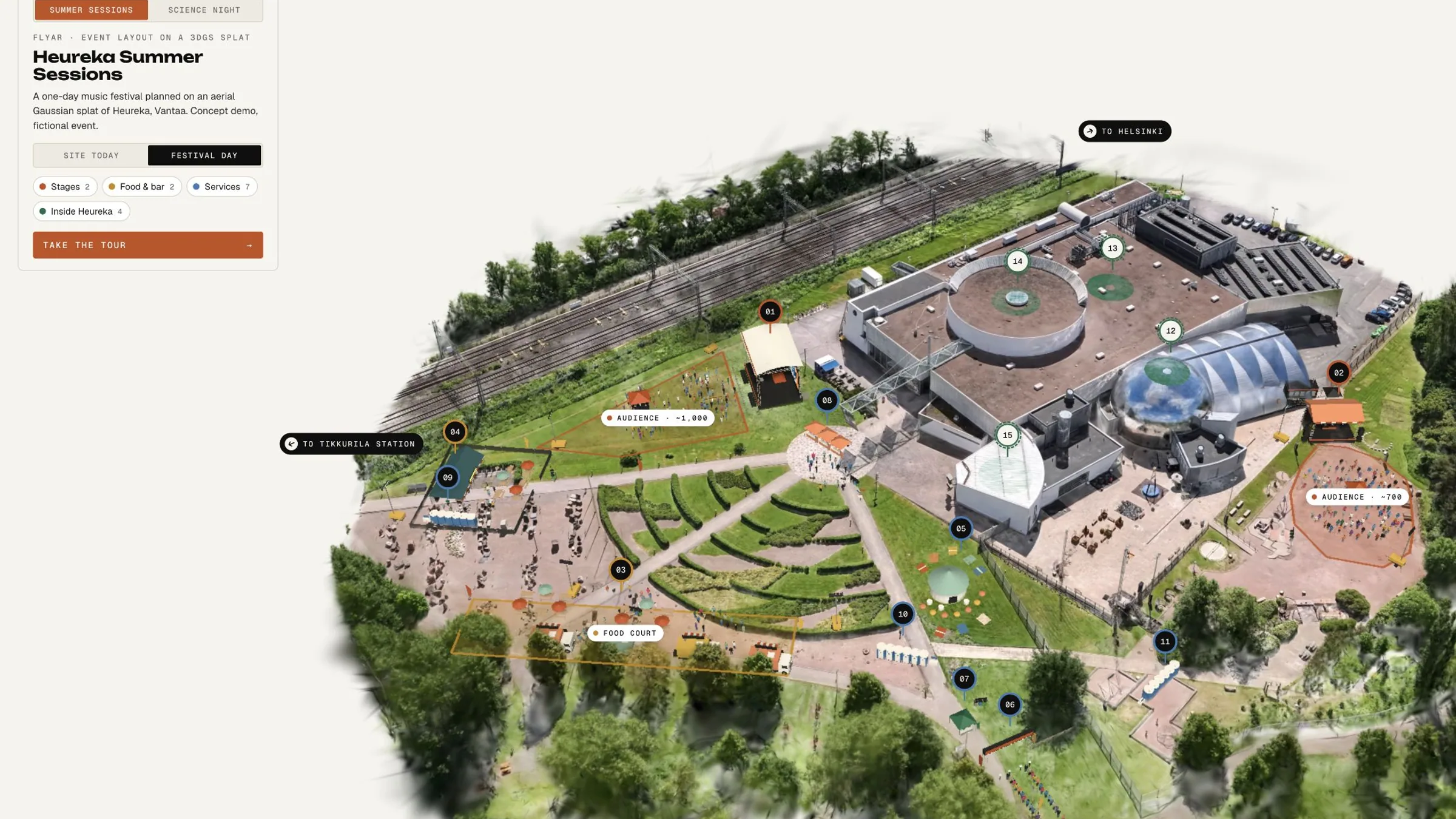
So we tried it. We flew a drone over Heureka, the Finnish Science Centre in Vantaa, turned the footage into a photorealistic 3D scene, and then planned two imaginary events on top of it.
Combining a scan with 3D objects
3D Gaussian splatting (3DGS) turns ordinary photos or video of a place into a photorealistic 3D scene you can move around in, right in the browser. Instead of triangles, the scene is made of millions of tiny, soft, coloured blobs ("splats"). Together they keep the look of a photograph: grass, trees, glass and gravel included.
Mesh is the classic 3D you know from games and architecture: modeled objects with clean edges, like a stage, a tent or a planned building.
The two do different jobs, and they're stronger together:
- The splat shows the place as it really is today, in true scale with real ground heights.
- The mesh shows what you plan to put there: stages, fences, toilets, food trucks, or a future extension.
Put them in the same scene and you can toggle between the site as it is and the site as it will be.
The demo: one scan of Heureka, two events
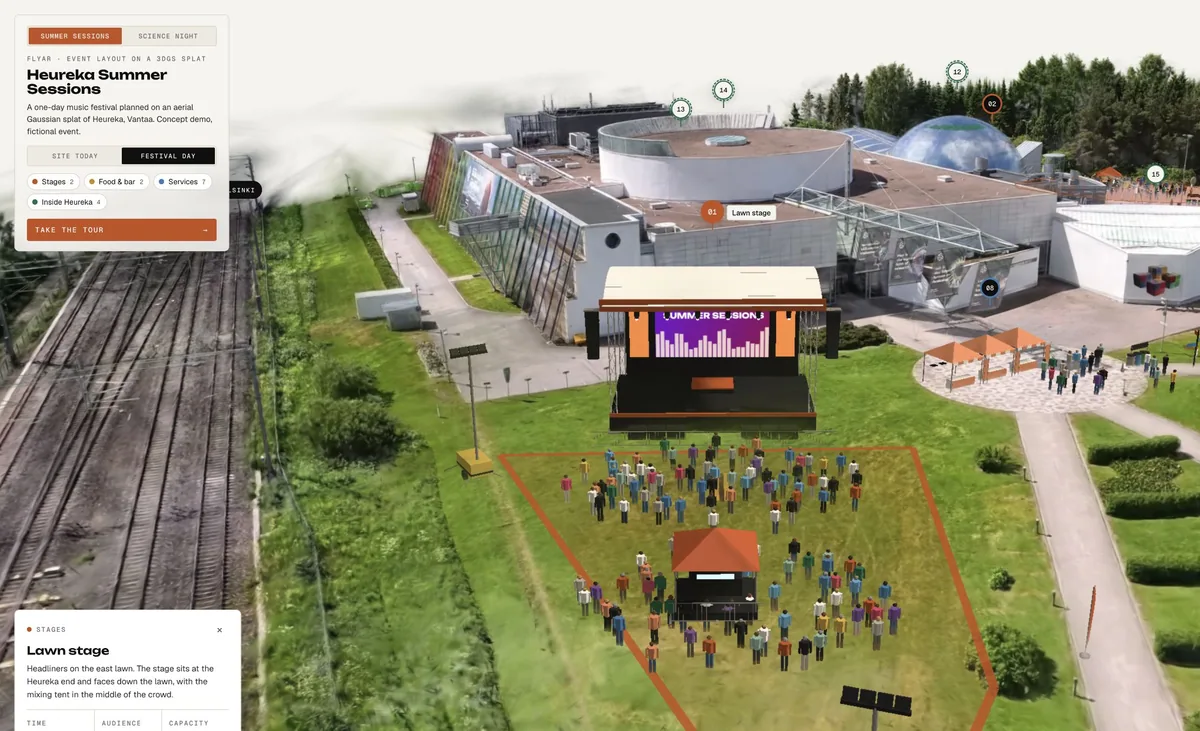
We flew a 360 drone over Heureka, extracted images from the footage and trained a Gaussian splat of the whole site. Heureka didn't commission this, and both events are made up, but the ground is real.
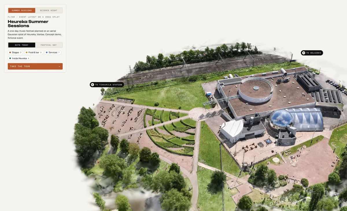
Summer Sessions is a one-day music festival with two stages, a food court, a bar and services. Science Night is an evening expo with an experiment street, a night market, a screen stage and a drone show over the lawn beside the commuter railway. Same ground, completely different layouts, and you switch between them with one button.
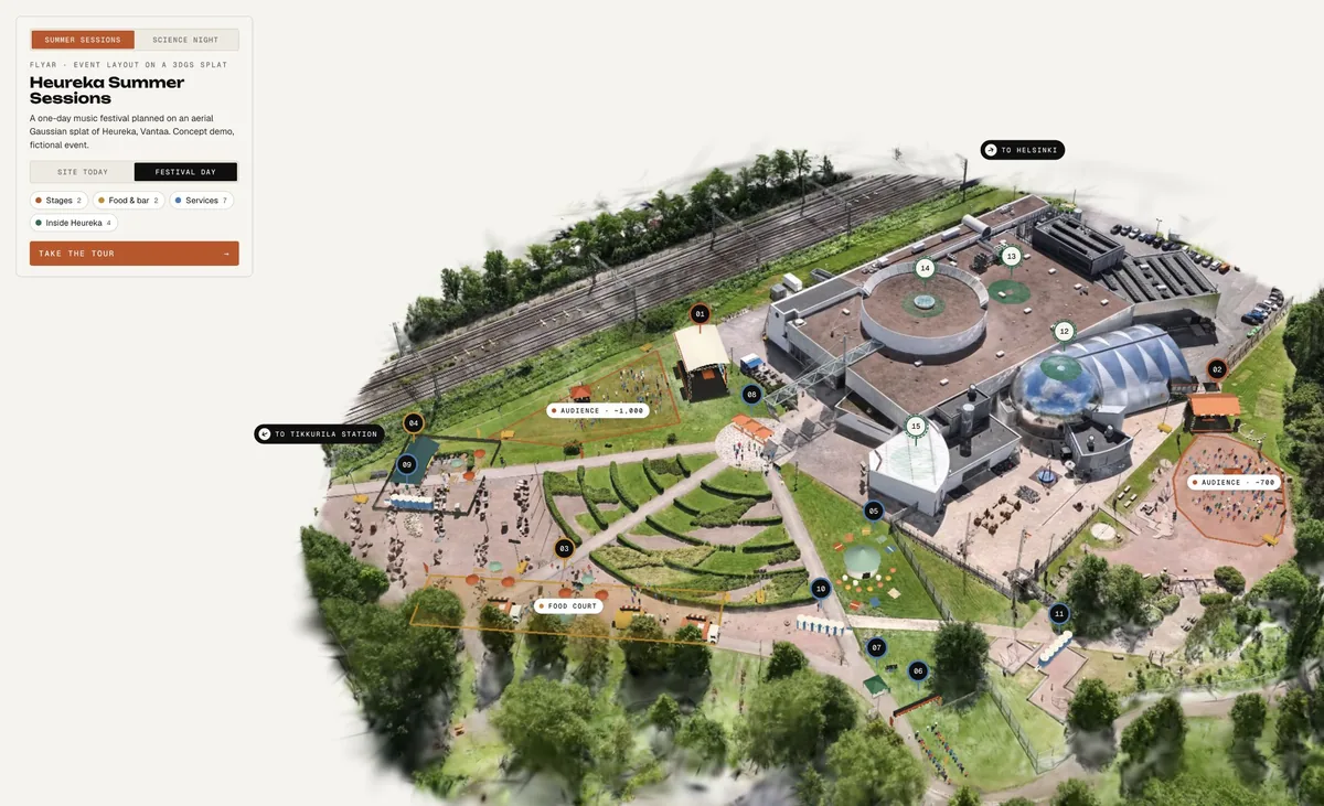
The stages, tents, fences and crowds are simple true-scale blocks placed on the splat. That's deliberate. At the planning stage you need to know whether things fit, not what colour the toilet doors are.
A few things we added because planners and visitors actually ask about them:
- Site today hides the event and shows the bare scan.
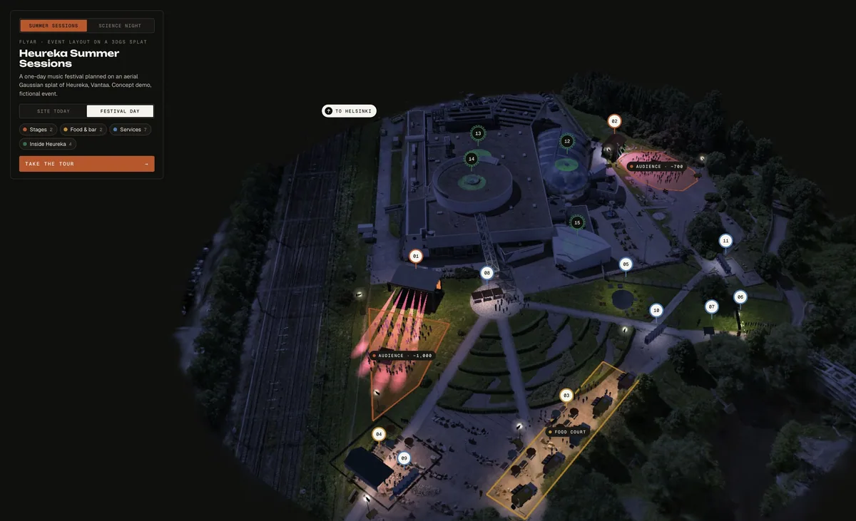
- Day and evening modes, with stage lights, lamp glows and lit trains.
- Pins and zones for the practical questions: where's the stage, where can I eat, how do I get here?
- A guided tour you can step through with the arrow keys.
The whole scene loads about 28 MB and opens from a link, an embed or a QR code.
The same trick works for permanent changes, too. Model a planned hall, a new entrance or a renovation as mesh on the scan, and the board can toggle between today and tomorrow instead of comparing renders.
Open the venue & event map demo
Under the hood
The demo started on 4 October with a simple brief: show Heureka as a small festival ground. By 19 October it had become one scan, two events, day and night. A lot of the work was done by an AI agent (Claude) through the PlayCanvas editor, with me sending feedback and screenshots. A few things we learned along the way:
- The scan doubles as a measuring tool. We read ground heights straight from the splat (the median height of the points in a 1.5 m square), and every stage, food truck and zone sits on that. The main lawn turned out to be about 75 m long with a 1.6 m drop. We even found the train tracks in the point data, then had the trains tilt to match the track bed.
- Night without a night flight. The scan has daylight baked in. A small shader dims the splat colours toward blue and paints warm pools of light around the stages, food and lamps: 14 for the festival, 18 for Science Night. Add stage beams and lit trains, and you get a convincing evening without capturing it again.
- Lighter, then faster. Thinning the splat from 3.53 million to 1.55 million splats cut the file from 53 MB to 24 MB. Combined with a pixel-density cap, it took the scene from about 22 to about 50 frames per second on my Mac.
- Props are code. Stages, tents, fences and crowds are generated by about 500 lines of Python, so a size change is a code edit and a four-second rebuild.
- The drone show cheats, nicely. 520 drones trace the flyAR logo. As the logo turns edge-on, every drone swaps to its mirror position, so it reads the right way round for the whole spin.
For venues: be the easy one to book
Event planners already shortlist venues online, and the big platforms know it. Cvent says 155K+ planners source venues on its supplier network, and it sells 3D venue tours to help venues stand out there. Those tours are built from the venue's floor plans and property details and rendered by 3D artists. (Cvent)
That works well indoors. It gets harder with what isn't on a floor plan: lawns, parking, slopes, beaches, the walk from the station. A drone-scanned splat captures all of that as it actually is, and it's in true scale, so planners can measure and place things on it.
The hotel group Lindner shows the kind of payoff venues can expect from 3D. After linking its 3D tours to its Google Business listings, it saw 25% more clicks. It also built a mini-map that takes conference clients straight to each space, and stages event rooms virtually to show different layouts. (Matterport case study)
What a venue gets from one scan:
- A sales asset. Send the link with every offer, or embed it on the venue page.
- A planning base for every client. Each organiser plans on the same scan, and you don't need to scan again for the next event.
- Fewer site visits that go nowhere. Planners who've explored the site online arrive with better questions, or rule you out early and save everyone a trip.
For festival organisers: one map, three audiences
Picture a typical Finnish outdoor rock festival. Three stages, a beach, a sauna, a camping area, food and bar zones, and a parking field that turns into mud if it rains. Now picture the PDF site map that tries to explain all that.
With a scan of the grounds, the same 3D scene can serve everyone who needs to understand the site:
| Who | What they use it for |
|---|---|
| The production team | Test stage positions, sightlines, crowd flow, emergency routes and backstage logistics before anything is built |
| Partners, permit and city teams | See the plan on the real ground instead of decoding a 2D drawing |
| Festival-goers | Find the stage, the sauna, the toilets and their tent, before they arrive and while they're there |
The visitor map works from a link or a QR code on site, so nobody has to install an app to use it. (We've written about what app installs cost you.) And because the scan is reusable, next year's layout is a new set of blocks on the same ground, not a new project.
What to plan for
- Permissions come first. Drone flights need the landowner's OK and have to follow aviation rules. Some sites, like those near airports, need extra permits. We sort this out before anyone books a flight.
- Weather and timing matter. Bright, even light and calm wind give the best scans. Leaves, water and reflective glass are harder, and an empty site scans better than one full of people.
- It's not a survey. A splat is accurate enough to plan on and photorealistic to look at, but it isn't a land survey. For engineering-grade measurements you still need a surveyor.
- Big sites need some thought for phones. The bigger the area, the more we optimize, so it still loads quickly on a visitor's phone in a field with patchy 4G.
And two caveats from our own demo. The crowd figures (about 1,000 people on the roughly 720 m² main lawn) come from a rule of thumb, not a crowd-safety calculation. And an aerial scan doesn't show the inside of buildings, so indoor spaces need their own capture.
FAQ
What is an interactive 3D venue map? A photorealistic 3D scene of a real venue that people can explore in a web browser. It can include pins, zones, routes and event layouts, and it works on desktop and mobile.
How is the venue captured? With a drone flight over the site. Images taken from the footage are trained into a 3D Gaussian splat, then cleaned up and optimized for the web.
Can we show different event layouts on the same scan? Yes. Stages, tents and services are added as true-scale 3D objects, and you can switch between layouts or hide them to see the site as it is today.
Do visitors need an app? No. The map opens from a link, a website embed or a QR code on site.
How long does it take? Typically 1 to 4 weeks for a destination or venue tour. Weather, permissions and the size of the site affect the schedule.
Can we reuse the scan? Yes. The scan is a reusable asset: new events, new seasons and future building plans can all be layered on the same capture.
Running a venue or a festival?
Have a venue you'd like to show this way? Send us the location and what you need the map to do. A few site photos will help us see where to start.
Send us a project note or book a 30-minute call. More on our Destinations in photorealistic 3D and Aerial Gaussian Splatting pages.